Latest Weather Analysis of Visayas Typhoon Center
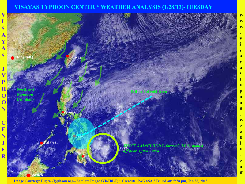
Cebu, PHILIPPINES - The weak low pressure area which has been monitored last saturday has finally dissipate, it was last located east of CARAGA Region, this remnants of LPA is expected to bring scattered rains across CARAGA Region, Davao Region and even in Bukidnon. Going also in Visayas expect scattered rains across Eastern and Central Visayas, this rains is caused by a tail-end of cold front (buntot ng cold front-in tagalog). Meanwhile Western Visayas will experience partly cloudy with brief isolated rains. In Luzon especially on Eastern sections expect light rains with decreasing temperature.
Here are the 5 areas/places experienced low temperature yesterday -- PHILIPPINES
Baguio City (12°C)
Basco, Batanes (16°C)
Malaybalay, Bukidnon (18°C)
Itbayat (19°C)
Tanay, Rizal (19°C)
WEATHER OUTLOOK FOR TOMORROW
(This forecast is not 100% accurate)
LUZON.
Bicol Region, Cagayan Valley, Aurora and Quezon Provinces -> partly cloudy skies with light passing rains. Chances of rainshowers will be 20-40%
Rest of Luzon including Metro Manila -> fair with a small chance of precipitation (10 - 20%)
VISAYAS.
Eastern and Central Visayas -> cloudy skies with light to moderate to at times heavy rains. Chances of rainshowers will be 60-90%
Rest of Visayas -> cloudy skies with isolated light rains. Chances of rainshowers will be 45-80%
MINDANAO.
Eastern and Central Mindanao including Misamis Oriental and Bukidnon -> cloudy skies with light to moderate to at times heavy rains. Chance of rainshower will be 60-100%
Rest of Mindanao -> cloudy skies with light rains. Chances of rainshowers will be 45-80%
NEXT UPDATE WILL BE WEDNESDAY, JANUARY 30 2013
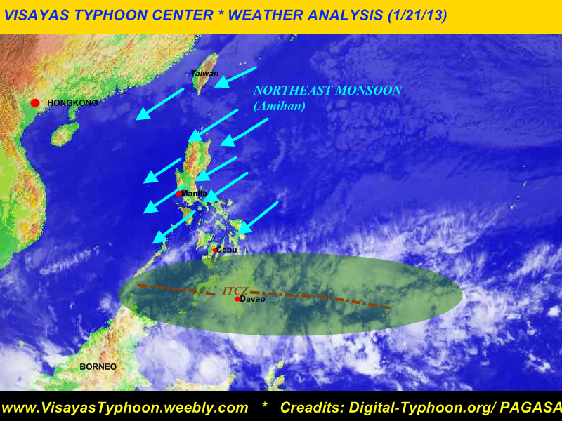
VISAYAS TYPHOON CENTER WEATHER ANALYSIS (1/21/13)IN THE PHILIPPINES
Cebu, PHILIPPINES - The weather system that bring heavy rains across Mindanao today, is not associated by a tropical cyclone/typhoon [as other people thought there is a cyclone name Cocoy]. Because as you could observe in the satellite image only the ITCZ (Intertropical Convergence Zone) is affecting Mindanao. According to the PHILIPPINE INFORMATION AGENCY-- REGION 11, there was one (1) casualty reported while 777 people were evacuated from 11 affected barangays in the province.
This rains is expected to affect Eastern and Central Visayas tonight or tomorrow. Latest tweet from PAGASA say's that there will be light to moderate rains expected over Leyte, Bohol and Cebu.
Going also to the north especially over Cagayan Valley, Aurora, Quezon Province and Bicol Region expect light passing rains and windy weather. Meanwhile the rest of Luzon will experience fair weather with brief isolated rain's. [[PAGASA recorded the lowest temperature for the month of January 2013 in Metro Manila (18.8°C)]]
Latest Gale Warning issued by PAGASA said that strong to gale force warning is expected to affect the whole seaboards of Luzon, eastern seaboards of Visayas and Mindanao so fishing boats and other small sea crafts is not allowed to venture to the sea.
AGAIN there is no tropical cyclone affects Mindanao today.
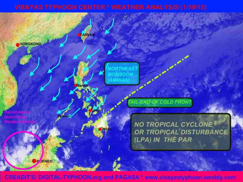
Cebu, PHILIPPINES- The low pressure area (tropical disturbance) which has been out the PAR yesterday, has entered again the PAR and spotted at 150km SE of General Santos City. According to the 24 hr. forecast track of Japan Meteorological Agency, this system will move eastward. The LPA also is embedded along the Inter tropical Convergence Zone [ITCZ] which bring rains across Visayas and Mindanao specially on the southern portions. Going also to the north (LUZON) there is also tail-end of cold front and the NE monsoon affecting to it so expect light to occasional moderate rains.
On the other hand there was also a tropical disturbance outside of PAR (about 1,190 km east of Mindanao), this LPA is expected to enter the PAR tomorrow afternoon or evening, there is also a chance that this LPA will be dissipate.
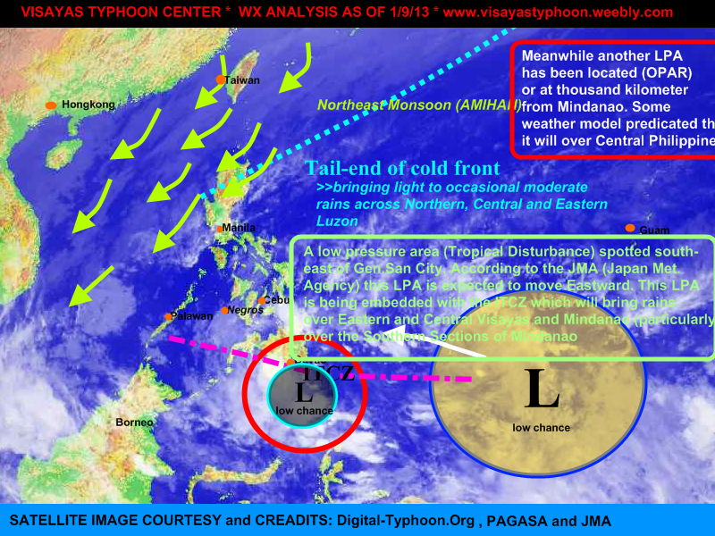
CEBU, Philippines - The tropical disturbance that has been monitored yesterday by PAGASA, has enter the Philippine Area of Responsibility, Saturday afternoon. According to the NOAA (a weather portal in USA), the system packed a winds up to 28kph. It's central pressure is estimated to be at 1010 mb, they also located the LPA at 4°N, 136.5°N; meanwhile the PAGASA located it at 6°N, 136°E. The said disturbance is embedded along the Intertropical Convergence Zone that bring rains across the Mindanao and Central visayas. Going also to the north, light to occasional rains shall be expected due to the Northeast Monsoon (Amihan)
VISAYAS TYPHOON CENTER '94W' Probability of becoming a tropical depression: 35% (LOW)
RAINSTORM WARNING #1 (heavy rains will be expected within 12 to 24hrs.)
MINDANAO: Compostela Valley, Davao Oriental and Samal Island
[Note: Do not use this warning in life decision, Kindly refer to PAGASA for the official weather warning]
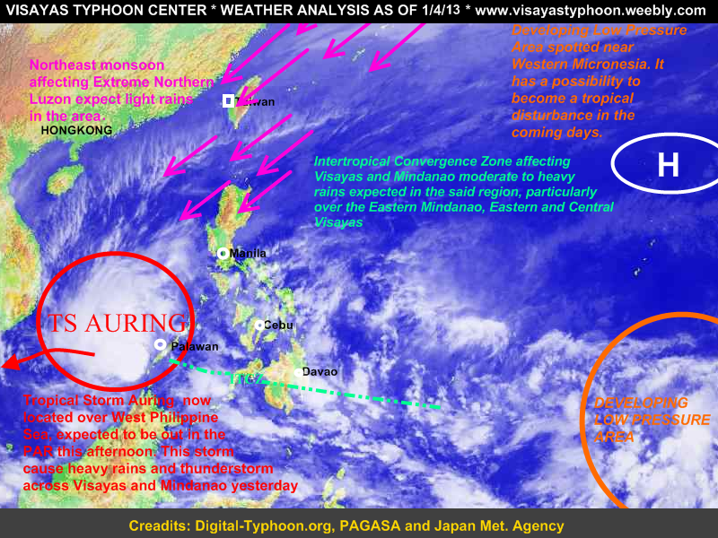
Cebu, PHILIPPINES- Tropical Storm Auring has made landfall over Southern Palawan, now located over West PHL Sea. It is expected to be out in the PAR this afternoon.
(Public Storm Warning Signal #2 over Southern Palawan, while the rest of Palawan is under signal #1)
Meanwhile Visayas and Mindanao shall still expect moderate to heavy rains especially in the Eastern sections of Mindanao and the Eastern and Central Sections of Visayas. Going also here in the Northern Luzon expect light rains because of the Northeast Monsoon, while the rest of Luzon expect fair and good weather
As we could see in the satellite image a developing low pressure area near Western Micronesia this system is expected to become a tropical disturbance in the coming days.

 RSS Feed